Information extracted from a pamphlet produced by the Glenmalure PURE Mile Group which was kindly sponsored by local individuals and businesses.
Welcome to Glenmalure and the Drumgoff, Ballyboy, Ballinafunshogue PURE Mile. The PURE Mile is an environmental initiative of the PURE (Protecting Uplands and Rural Environments) project which aims to foster a greater appreciation and awareness of our country roadscapes. This pamphlet will introduce you to the history, culture and rich biodiversity along this special stretch of road. Our PURE Mile begins at Drumgoff Bridge, continues to the crossroads at Glenmalure Lodge, turns to the left into the valley and continues along until you reach the Carrawaystick Waterfall. Our aim is to guide you along our PURE Mile using the descriptions and pictures to self-locate, so you can experience some of what this special area has to offer while you walk.

The Pure Mile
In the Beginning
The Glenmalure valley was formed about 10,000 years ago from the effects of glaciation during the last Ice Age. This resulted in the straight, flat-bottomed valley with its steep sides that we see today. Running in a west — east direction and over 8km long, it is recognized as the longest glacial valley in Ireland. The surrounding rocks of granite and schist were formed hundreds of millions of years earlier. The PURE Mile begins and ends with two particular geological features. At the start, we have a good example of a glacial moraine on which the Drumgoff Barracks now stands. The end of the PURE Mile is dominated by the Carrawaystick Waterfall which originates from a hanging glacial valley. In between, we have the Avonbeg River and surrounding fields all formed from the action of the last Ice Age.
Start: As you stand on Drumgoff Bridge (1), the half-way point of the Wicklow Way, with the Avonbeg River meandering gently beneath your feet, you are standing on the old Military Road which ran from Rathfarnham in Dublin to Aughavannagh. The road was built following the 1798 rebellion to open up the mountains to the English military, to assist in the capture of insurgents who remained active in the Wicklow Hills. A number of barracks were built along the route, and here you will see the ruined remains of Drumgoff Barracks (2) surrounded by lime and sycamore trees. These buildings were to provide shelter and protection to the soldiery hunting the remaining rebels, one of the most famous of which was Michael Dwyer. Looking ahead to your right you will see the Glenmalure Lodge, under the back drop of Carriglinneen Mountain (4), which has stood here since the 18th century when it was built as a coaching inn. On the slope to the left of the Lodge you will see a large outcrop of rock; this is known as Dwyer’s Chair (8). Michael Dwyer was made captain of the United Irishmen in 1798 and local stories are that he used the rock as a vantage point from which he viewed the comings and goings of soldiers in the barracks to evade capture. He succeeded in doing so until 1803, when he negotiated a surrender. However he was deported to Australia where he later became police Chief Constable of Liverpool, New South Wales in 1820. At this point you may also be lucky enough to catch a glimpse of one of the otters who inhabit the river below. They can be very elusive and are most active after dark.

Drumgoff Bridge
Proceed towards the crossroads and turn left into the valley along the ‘Glen Road’. From this point onwards on your right hand side (RHS), as far as ‘The Chute’ (10), is a native woodland and therefore protected as a Special Area of Conservation (SAC). It is also listed as a ‘Special Protected Area’ (SPA) due to the presence of merlins and peregrine falcons, both birds of prey.
Walking as far as the first field gate on the left is what is known locally as the ‘Scrub Bank’. From this point you can look back towards Drumgoff, and you will see the arches under the bridge & Fananierin Ridge (3). To the right you will see a private residence which was once the forestry office (5).

Scrub Bank
Continuing you come to the 2nd gate on the left hand side (LHS). Looking into the field you will see a gravestone standing alone in the field. This is the ‘Kavanagh Brothers Grave’ (6), who were put to death in 1798. Some say they were innocent victims, being men returning to their native County Wexford, having been working in Dublin, and had no association with the “Rising”. At this point if you turn around and look towards the top of the trees behind you, you should see the edge of Dwyer’s chair (Carrigurtna) (8) protruding over the trees. You might also spot a merlin, peregrine or raven who hunt around the rock, while jays and woodcocks live in the oak wood beneath.

Kavanagh Brothers’ Grave
A short distance along to your right you will see a granite boulder known as Cullen’s Rock (7). Local lore has it that it was kicked from across the river to its current position by a giant! It is also rumoured to have been used as a gallows to hang rebels. Today you will see that it is used as a memorial stone for Michael Dwyer & Fiach McHugh 0′ Byrne, which was unveiled in 1939. The inscription, in Irish, on the nearside remembers Michael Dwyer and translates as “This glen was the stronghold of Michael Dwyer and his comrades in 1798”. While the inscription on the other-side translates as “This is the glen in which Fiach McHugh 0′ Byrne defeated the English in 1580” This refers to the Battle of Glenmalure in which Lord Grey set out to rid the valley of rebels in 1580, led by Fiach McHugh O’Byrne. The English army was decisively defeated in a rare example of a complete victory of an Irish army over their English opponents.

Cullen’s Rock
Further ahead there is abreak in the fields on the left, where the river flows close to the road. This is known locally as the ‘River at the Road’ (9). This area appears to be a favourite habitat for a range of animals including; foxes, badgers, hedgehogs and our native red squirrel. Dragonflies and damselflies are also commonly found here. You might also hear some loud ‘drumming’ coming from the trees to the right; this will be the greater spotted woodpeckers who have recently returned to area.

River at the Road
Walking ahead you will observe, in different spots, a lot of animal tracks crossing the ditch into the field on the left. These tracks belong to sika deer who come down from the forest to feed on the grassy fields. The boggy areas in the field are a good breeding ground for frogs and also a feeding site for wild mallard ducks and herons who feed on them and other water insects.
Further along you will come to a forestry entrance (10) on the right which connects with tracks for the Wicklow Way & Glendalough. Just before the forest entrance, at the point where the track meets the road, if you look to the right you will see a gap in the trees; this is called ‘The Chute’. Which gets its name from a timber chute (U-shaped channel) that stood here from 1948 to 1950 in order to transport felled timber to the roadside from high up on the hillside. This was a hazardous operation due to the steep gradient on the chute. Some of the timber poles would pick up considerable speed, and with very little control, would often end up in the field opposite or end up bouncing out of the channel completely while hurtling down the hillside!
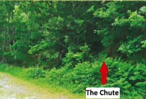
The Chute
Shortly on, you will pass by a memorial stone on your left for Margaret Sentinella, a hillwalker and a friend, RIP. On your RHS you will notice a large rock jutting out on the roadside; it is called the ‘Orange Stone’ (11). This is the reputed site where two protestant men, William Carter and Samuel Langrell, were piked to death by the Farrells of Clohernagh in retaliation for the killing of the Kavanagh Brothers on the previous day.

Orange Stone
Further ahead will you see an impressive Scots Pine (12) tree ahead of you on the left. There are a number of Scots Pine growing in the valley which are the remnants of the mining era in the 19th century. They were planted as the timber was used for support in the construction of mine shafts.

Scots Pine
Not far ahead, on the right, there is a flat granite stone (13), opposite the entrance to the 3rd house. You have to look closely, but this stone has ‘RIP’ engraved on it! Apparently there was a young Wexford man who was making his way home following a clash with the English. It was claimed that a local farmer helped this man, who worked for him in return. However an English solider who recognised the young man shot him in the field opposite. The farmer is supposed to have inscribed this inconspicuous RIP into the stone in memory of him.

Unnamed Gravestone
Just ahead you will reach the end of our PURE Mile. You will see Carrawaystick Waterfall with the picturesque cottage below, named locally as Kellystown. There was once a Flannel millon this site before it was burnt down in 1798 during the Rebellion. The mill was powered by a mill wheel in the waterfall, fed from Kelly’s Lake above. The burnt out ruin was later acquired by the Farrell family who came to work in the local lead mines at the time. The ‘zig zag track’ leading up the side of the mountain (Corrasillagh) was built by John Parnell, father of Charles Stewart Parnell, for access to the mountain for hunting grouse and deer, taking turf off the hill and getting sheep & cattle up and down.

Kellystown Cottage
Flora and Fauna of our PURE Mile
Much of the route is surrounded by trees and forestry. The left hand side of the valley, across the river is mainly planted with conifers including; Norway spruce, Sitka spruce, lodgepole pine and larch. While along the right side of the valley is mainly native broadleaf woodland including; oak, ash, birch, rowan, holly as well as some nonnative beech and sycamore. This native woodland is an SAC and SPA. These are both EU designations which give these areas and their inhabitants legal protection. We are very lucky that we have a whole host of native wildlife in this area and while some have been mentioned in the route description many have not. These include; pine martens — Ireland’s rarest animal, pygmy shrew —the smallest Irish mammal, mink and 7 out of the 9 Irish bat species! There are also a whole range of bird species who have not been mentioned yet. These include the majestic red kite, now a common sight in the valley, kestrels and the wood warbler, as well as a variety of common songbirds There are a variety plants and wildflowers, which grow along the PURE Mile and will be in bloom at different times of the year. The most obvious being gorse which runs along much of the road ditch on the left hand side, with its beautiful yellow blossoms appearing from Feb to May. Fern species dominate the roadside in the late Summer. Wildflowers identified along the route include; foxglove, wood anemone, sheep’s-bit scabious, St John’s-wort, herb Robert, heath bedstraw and valerian to name but a few.
There are many other bird, plant and animal species who inhabit the area around our PURE Mile which we would love to be able to mention but unfortunately there’s just not the space here! We hope that this pamphlet will serve as an introduction to just some of what this special area has to offer, and hopefully you will find out more after you have discovered some of these sights along the way.

Fauna

Flora
We would like to take this opportunity to thank the members of the local community, both young and old, who gave the PURE Mile project their full support, which makes it all worthwhile. A massive thank you also goes to the local businesses and individuals who kindly sponsored the production of this pamphlet. Go raibh mile maith agaibh go lair!
Winner of the Best PURE Mile Award


No Comments
Add a comment about this page