Dunlavin and Donard - A Brief History of Some Civil Parishes in the Barony of Lower Talbotstown


This article has been compiled for the Heritage Office in Wicklow using sources including the Irish Tourist Association Topographical and General Survey 1943 (ITA)- Barony of Talbotstown Lower and Lewis’s Topographical Dictionary 1838 as baseline information.
These valuable historical records are stored in the Local Studies Collection of Wicklow County Council Library service and may be viewed by appointment.
Other sources include Wicklow History & Society (1994) Ed K Hannigan, W. Nolan and Historical Dunlavin – Chris Lawlor.
Dunlavin is a civil parish and a town in west County Wicklow. It is thirty miles south of Dublin and ten miles north of Baltinglass. This parish embraces the Glen of Imaal, Lugnaguilla, the Slaney and the hills of Tournant which overlook the plains of Kildare. Church mountain is also incorporated in this parish which has some of the remains of the church of Palladuis (the predecessor of St. Patrick). The town of Dunlavin is at the western extremity of the parish, Donard is in the centre and the Glen of Imaal is in the east. The entire parish is on high ground but the western portion is considerably lower.
Donard is a civil parish and a town in west Wicklow which at the time of Lewis contained 1,463 inhabitants of which 717 were in the village which is on the Little Slaney River. In 1798 the village was burnt and the inhabitants sought refuge in Dunlavin; the church was garrisoned by the yeomanry which led to its dilapidation.
Crehelp is a civil parish which contained 760 inhabitants at the time of Lewis. There were some slate quarries there and a ‘peace preservation force’ was stationed there. Tynte Park House is situated on the Tournant hills. It is a Georgian structure of the late eighteenth century.
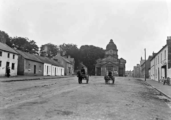
The village of Dunlavin was established by Sir Richard Bulkely in the late seventeenth century and his estate was taken over by the Tynte family who commissioned the Market House in Dunlavin in 1737.
Market House Dunlavin
This building is two storey Palladian Style and built from Richard Castle’s designs. It was later used as a courthouse and more recently as an art gallery. According to the National Inventory of Architectural Heritage it is constructed with rusticated ashlan granite and is topped with an octagonal domed lantern with roundels and clockfaces. The roof is finished with natural slate and has stone paraphets with dressed coping. The building has cast-iron rainwater goods. Dunlavin has associations with the 1798 rising when thirty six men were executed in the Fair Green, some were hung from the pillars of the Market House. A number of the bodies were buried in a common grave at Tournant Cemetery. A commemoration stone is situated in St. Nicholas of Myra Catholic Church near the green.
Leitrim Barracks 1800’s
The ruins of the military barracks still remains, this was built in 1803 to restrict Michael Dwyer’s (a key player in the 1798 rebellion) freedom and served as a garrison for his neighbourhood and placed a watch over the mountain road to Glenmalure. There was a new military road which was guarded by barracks at Glencree, Laragh, Glenmalure and Aughavanagh.
1798
In Dernamuck Michael Dwyer used Hoxey’s House as a refuge; he escaped when it was attacked by soldiers. All that remains of this wall is one gable and small pieces of a side wall.
Christian Settlement
St. Palladius was ordained by Pope Celestine in the fifth century and he established three Christian settlements in Wicklow including one at Church Mountain/Sliabh Gadoe and one at Cilin Cormac near Dunlavin. At Church Mountain in the time of Lewis numerous pilgrims were attracted by this area and also visited the nearby well. A monastery is said to have been established in Tober which is a parish near Dunlavin and it is said that the fishpond on the River Griese was constructed by Tober monks.
The King of Leinster requested Pope Adrian IV in 1155 to grant permission to King Henry II for an invasion of Ireland. The local Leinster families the O’Tooles’ and the O’Byrnes’ moved to the Wicklow mountains to places such as Dunlavin. The Normans settled in the lowlands and fortified the villages and towns against their attacks from the mountains.
Antiquities
The ITA refers to raths, castles, mottes, tumuli, the dolmen, ogham stones, bullaun stones, standing stones and graveyards as antiquities and information on these is summarised in the following paragraphs.
Raths
A rath is a circular earthen walled enclosure which historically served as a fort or a residence for an important person or ruler. The principal rath in this area is located at Donard Demesne east. This rath consists of three concentric rings and two ditches. The inner plateau is surrounded by the inner ditch which is about 8ft deep and has as a diameter of around 50ft.
Castles
Ballintruer Castle is situated off the road from Whitestown Cross to the Glen of Imaal. A portion of the north east corner remains in the centre of a field. The portion of wall remaining is very thick and built of heavy stone. It is thought that this was one of the castles belonging to the O’Tooles’. Not much remains of Castlequarter Castle which is near Ballyhubbock bridge. Remains may be at the back of a cottage where there is a very sharp embankment often associated with castles.
Dolmen
There is a dolmen situated a half mile west of Donard village it is visible from the main road from Phillips Cross to Donard and is known as the Bloomfield dolmen.
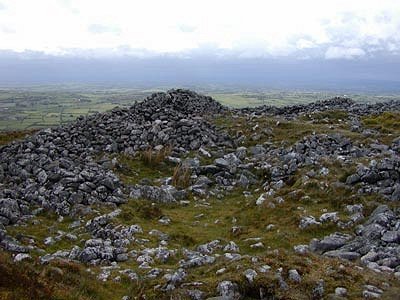
Ogham Stones
There are two Ogham stones in the parish. The first is in the Donard Demesne – see map (however the people of Donard have got permission to move this to the centre of the village where it now stands) and the second at Knickeen at the eastern side of the Glen of Imaal – see picture. The Ogham stones date to about the 5th or 6th centuries. The writing on the Knickeen stone spells MAQI NILI which seems to mean “Son of the Neill/Niall”, it is 8ft high and is situated just outside the army firing range ten to fifteen miles off the mountain track.
Stone Circles
The Castleruddery Pipers stone circle is situated 6 miles east of Dunlavin and 4 miles south of Donard, just off the road. Most of the stones are granite, some are pure quartz and others limestone.
This circle is unusual in that it is surrounded by a massive earthen bank. The entrance of this circle is formed by two large quartz boulders. From this stone circle one can see the Brussellstown Ring, which is a large hillfort, probably built 1,000 BC. This is one of a number of very large fortifications enclosing the tops of mountains in this part of Wicklow. Two other fine examples can be found at Rathcoran above Baltinglass and at Rathgall near Shillelagh.
The remains of a second circle is situated at Tournant near the summit of an old moat.
A third circle is situated in the townland of Forristeen two miles east of Dunlavin.
Earthen mounds and Tumuli (mounds of earth over graves)
There is an earthen mound a couple of hundred feet in length and 35ft high at Tober a mile and a quarter north east of Dunlavin. It runs east to west and rises to a circular motte of about 25ft. It looks like a large motte and bailey with well ridged sides and is believed to be a pre-Christian burial mound. At the front of the mound there is a small artificial canal or fish pond.
A second motte is about 25ft high and sits on the southern part of the hill of Tornant; it is a ridge running north to south, surrounded by a ditch. This site was believed to have been the part of the Royal residence of the Kings of Leinster until a short time after the advent of Christianity.
A third motte about 25ft high and 40ft in diameter is situated at Lemonstown two and a half miles north east of Dunlavin. This mound is a landmark, visible from Poulaphuca with a ditch at the base.
There is another well-formed motte with a paraphet on top. It is located at the southern end of Donard village and it is about 20ft high and 40ft in diameter.
A fifth motte about 35ft. high is located at Ballyhubbock bridge below Castleruddery crossroads and is visible from the road leading from Whitestown Cross to the Glen of Imaal. It is built a few yards from the banks of the river Slaney.
A sixth motte is situated in the north west corner of the Glen of Imaal at Drunree. It is about 16ft high and its eastern side is flush with the edge of the cliff leaving a sheer drop of about 90ft. Around the other sides there is a deep trench about 10ft wide. The summit has been hollowed out to a depth of a few feet leaving an earthen wall about 2ft wide to form a circumference. Its diameter is about 40ft.
Bullaun Stones
These have been found at:
Intack in a field a mile north of Donard in a field on the right hand side of the road which has two raths. It has holes of about 1in. in diameter.
Other stones of possible significance are situated on the southern side of Donard at Creghorn, half way between Davidstown and Donard. To the west of the centre of the field there is a long slab stone about 5ft long and narrowing to 2ft. There are three circular basin like holes on the surface measuring about 1ft. The possible other part of this slab lies a few yards away. There may have been a monastery at this site also.
About 20 meters away there is another bullaun shaped stone. There is a rock nearby sharply divided in two and the division between them is about 1ft. There is a complete circle around the whole stone for a depth of 8ins filled with small pebbles lying on a raised surface.
Knickeen Stones
At north eastern corner of the Glen of Imaal at Brittas Corner in a field on left hand side of the road there are two stones, one near a stream running through the field it has four holes in it.
Another stone with three holes is a few meters away.
Standing stone
A standing stone lies three and a half miles east of Dunlavin in the townland of Crehelp, it is 5ft high and is made of granite. An oblong pole pierces this standing stone.
Graveyards
The graveyard surrounding the ruined protestant Church at Donard has a number of interesting stones according to the ITA survey. One of the stones in this graveyard which has two crosses is thought to be the grave of St. Sylvester who according to Lewis, is thought to have been a follower of St. Palladius who was a precursor of St. Patrick who visited West Wicklow and founded a church at Donard about 430AD.
Commemoration Stone
There is a stone in the Protestant Church in Dunlavin embedded in the vestry wall in 1681. This was a gift by a parishioner for the rebuilding the chancel of the church.
Patterns/Customs – Well
There is a well dedicated to St. Nicholas of Myra about a quarter of a mile east of the town of Dunlavin. There used to be Pattern (a pre-Christian ritual associated with Wells), associated with this Well but is now discontinued. Various cures such as the cure for toothache were ascribed to the Well which would not be uncommon. There was a path through the field opposite the parish priest’s house leading to the well.
Finally the ITA Survey 1943 dealt with local information in 1943 some of which is relevant today. For example:
- There was Brown trout and Salmon in the Donard River
- Coursing meetings were held annually
- Shooting including ‘rough shooting’ took place of grouse, partridge, pheasants and wild duck
- The Kildare Hunt operated in this district
- The Dunlavin train station was still operational
- Dances and film showings were held in the Imaal Hall


No Comments
Add a comment about this page