Prior to 1960, Wicklow was the premier mining county on the island of Ireland. This was based in part on the substantial production of copper and sulphur from the Avoca district. It also reflected the lead output from several veins along the eastern margins of the Wicklow Mountains and centred on Glendalough (Map 1).
Map 1: Simple geological/location map of Wicklow showing mine sites
The rock sequence containing the mineralisation of County Wicklow is at least 500 million years old and it records the plate tectonic history of the Earth’s crust over the period 535-400 million years ago. This history involved the opening of an extensive ocean (the Iapetus Ocean) about 480 million years ago as two plates of the Earth’s crust moved apart. Landslides and volcanic eruptions deposited mud and sand along the ocean floor, building up large volumes of material. Immense weight was exerted on the lower levels of these deposits compressing it into rock, forming mudstones and sandstones (types of sedimentary rock). Slowly the ocean closed as the plates came back together again, leading to the deformation and heating of the rocks as well as the intrusion of granites such as the Leinster Granite. In all of this time, Wicklow was situated on the southern margin of this ocean (Fig. G1).

Fig. 1 G1 Cross section of Iapetus Cocena showing formation of Wicklow Granite and Avoca Volcanoes
The bedrock history of Wicklow effectively finished around 400 million years ago when the Leinster Granite was intruded and cooled down. The granite now forms the central core of the Wicklow Mountains.
Avoca lay close to the boundary between these two colliding plates and was the site of much volcanic activity. The volcanic ashes accumulated on a seafloor where jets of metal-rich, superheated waters were injected into the cold seawater, causing the metals to be deposited as a thin layer of sulphides (Fig. G2).

Fig. G2 Mineralising Black Smokers similar to those that formed the Avoca Deposits
Unprocessed copper occurs mainly as chalcopyrite, or fool’s gold, composed of copper, iron and sulphur. The ore typically contains 1% copper or less, generating an awful lot of waste ore in mining. Pyrite, an iron-sulphur mineral valued for its sulphur content, was originally used for making gun powder but more recently has been used in fertiliser production. Lead and zinc occur with the copper in minor quantities but neither have been recovered commercially at Avoca. Ochre, naturally occurring yellow-brown pigment consisting of iron oxides and kaolin, forms the near-surface of the copper and pyrite deposits and was mined on a small scale until the 1940s.
The lead-bearing veins of southeast Ireland are largely concentrated in County Wicklow but they also occur elsewhere. In the Leinster Granite they are confined to its eastern margin close to the junction between the granite and the surrounding rocks (schists). The lead-bearing veins are composed of galena (lead sulphide), sphalerite (zinc sulphide) and pyrite (iron sulphide) along with the non-economic minerals quartz and calcite (Fig. G3).
Fig. G3 Lead Veins underground at Glendalough
The Wicklow lead-bearing veins all occur in granite close to the junction with the surrounding schists. They are typically situated close to the courses of major fracture zones in the rock.
Human activity has led to the commercial extraction of copper and lead ores from the County Wicklow over the past 200 years. However these mineral ores were originally either buried by later rocks, in the case of the Avoca copper deposits, or were formed at a depth below surface of 5-10km, in the case of the lead veins. That was until the geological processes that led to the erosion of this landscape exposed the mineral deposits at surface and made their extraction feasible. Geologists have established that an uplift of the Wicklow Mountains occurred between 36 and 10 million years ago, associated with the opening of the present day Atlantic Ocean. During the uplift, the rocks overlying the mineral deposits were eroded. Only the glacial sculpting of the Quaternary Ice Age, which ended over 20,000 years ago, modified the landscape significantly, providing the steep valley walls where veins could be feasibly mined (Fig. G4).
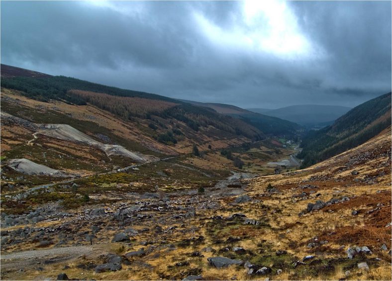
Fig. G4 U-Shaped Glacial Valley (Glendasan)


No Comments
Add a comment about this page